

Little River: Wild and Free atop Lookout Mountain
- Sep 12, 2017
- 8 min read

Little River: Wild & Free atop Lookout Mountain
Little River, which is said to be one of the cleanest and wildest waterways in the south, flows for its almost entire length dropping over 1,250 feet down the middle of Lookout Mountain. The river forms an extensive canyon and gorge system that is up to 600 fee deep from the top of sandstone cliffs to the canyon floor. Its headwaters begin in nearby Georgia and it carves its way through one of the Southeast’s deepest canyons as it winds its way down thru Alabama. The main stem of the river is formed by the confluence of the 17-mile long East Fork and the 25-mile long West Fork. The river then flows another 23 miles before it eventually empties into the Coosa River at the Weiss Lake impoundment near Leesburg, Alabama. The river is undammed aside from an old hydroelectric project at Desoto Falls near Mentone, Alabama and is considered as one of the South’s cleanest waterways.
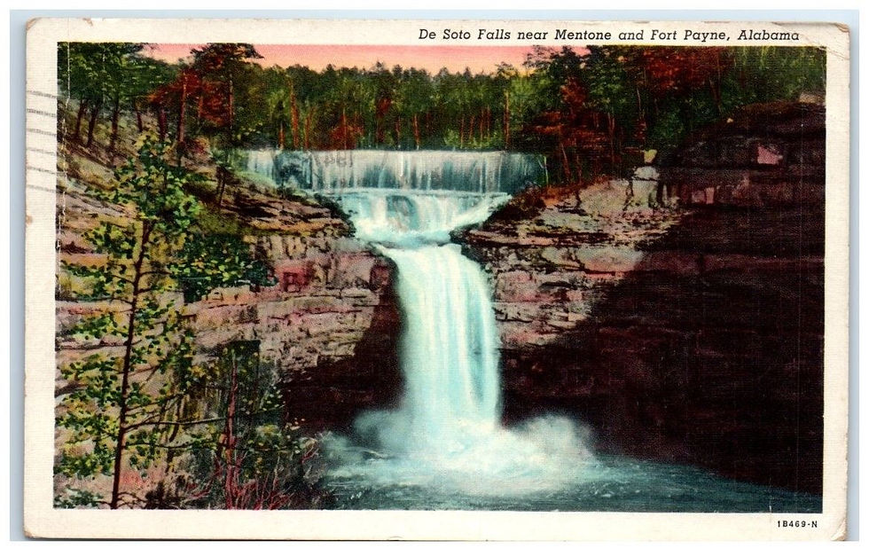
The river boasts three large waterfalls along its journey and has spectacular canyons. The first of these falls is DeSoto Falls. It is located near the town of Mentone and it drops 104 feet into the West Fork of Little River. It then meanders its way a few more miles downstream making its way into the heart of Little River Canyon. The falls are named after Hernando DeSoto who explored the nearby Coosa Valley in 1540. In 1863, Union Cavalry Troops under General William S. Rosecrans camped on the West Fork of the Little River just above DeSoto Falls as they advanced on Chattanooga and eventually the Battle of Chickamauga. Troops noted at that time in journals that the falls were also known as Indian Falls.
We know that Native Americans cherished DeSoto Falls long before Europeans even knew it existed as artifacts have been found nearby that date back to over 2000 years. There are even ruins of cave dwellings that still remain below DeSoto Falls and were first written about by Albert James Pickett in his book, History of Alabama, in October 1850. It is speculated that these caves may have been built by the Welsh before DeSoto’s famous explorations. The caves are located in a cliff approximately 325 feet above Little River, below the falls. There are five caves located side by side with three of them interlocking by openings connecting each. They are protected by the cliff in which they are carved and by the only trail to them. The trail is 90 feet long and is so narrow that only one person can pass at a time. The trail averages in width two to five feet, and in some places is precarious and slippery. The cave was once protected by two stone walls located in a semi-circle in the area surrounding them. The walls are believed to have been four or five feet high at one time. All that’s left of the walls now are mounds with occasional rises with jutted rocks. According to locals, the walls were built up fairly well at one time however the stones of the walls were carried off by people for use as stepping-stones or to build chimneys. Some local historians say that Native Americans could not have built the caves due to the fact that none of the tribes of this area were familiar with the art of excavation. There is legend and folklore that Prince Madoc (Mad dog), who was a Welsh explorer, may have landed in Baldwin County, Alabama long before Hernando DeSoto. Scientists have determined that timber found within the caves had been cut by axes centuries before the Spanish came to the New World. Historically, one author wrote that the caves were part of a dreadful war, and those who constructed them, to have acted defensively. The caves are situated so that, in ancient times, 20 men could have held off an army of thousands. Archaeological research by Jacksonville State University determined that the Welsh Forts were likely built by Native Americans of the Woodland era in 1000 B.C.-900 A.D. So who built the walls and inhabited the caves? Native Americans, the Welsh and Madoc, or the Spaniards and DeSoto? No one can say with 100% certainty but one thing for sure is there is a great view from the bluff. Not far from the falls is a trail that is accessible to Icebox Cave and the Welsh Caves. It also offers a spectacular view from the far side of DeSoto Falls.
In the 1920’s, a self educated electrical engineer, Arthur Abernathy Miller built a 20 foot high dam just above the falls. He built the dam to help supply power for his hydroelectric generator which was just below the falls. If you visit the falls today you can cross the top of the dam and take the trail down to the bottom where you will find a concrete base where power was generated to supply the Alabama towns of Fort Payne, Mentone, Valley Head, Collinsville and Menlo, Georgia. Arthur Miller and his partner also purchased 300 acres surround the falls to eventually divide into building lots. They had plans for a community and to build a fortress below the falls. However, the great depression played a big role in the demise of that project.
Desoto Falls is located off the Lookout Mountain Parkway on County Road 613 not far from Mentone. From the parking lot, the waterfall overlook is reached via a paved pathway which extends for a few hundred yards. DeSoto Falls and the lake above it are a popular place for locals to swim, along with cavers for rappelling in the summer. If you would like to rappel at DeSoto you must stop by the park, which is located 12 miles south of the falls and sign a waiver first. The lake above the falls also offers opportunities for paddling up stream.
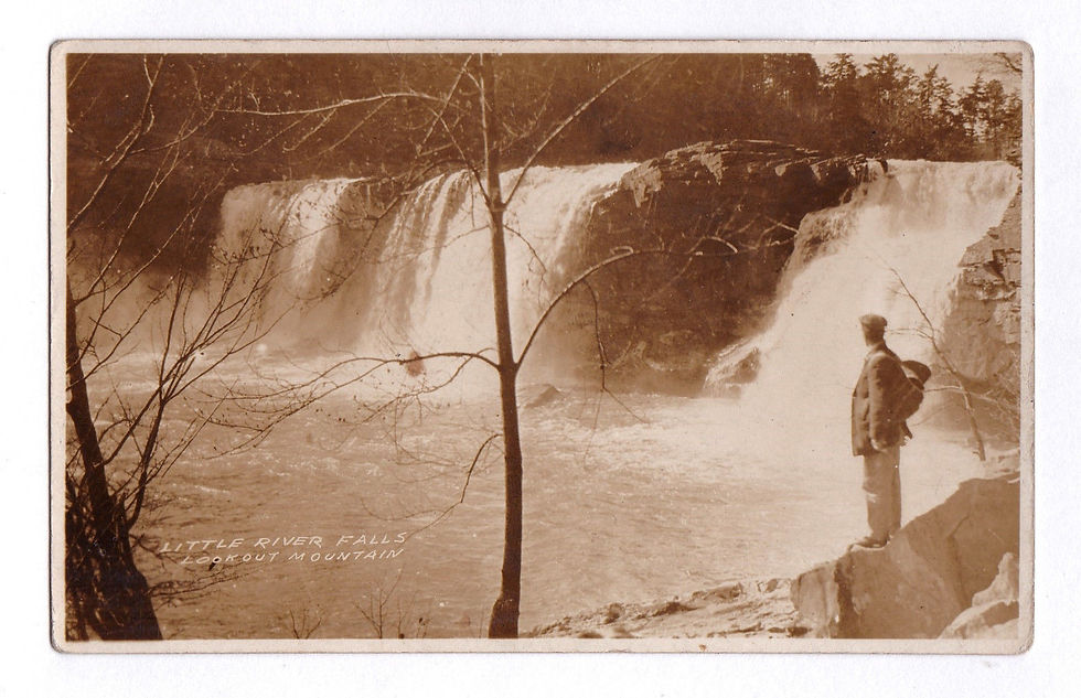
The next waterfall along the river is Little River Falls, which can be found at the head of Little River Canyon. In 1969, the Alabama legislature designated the section south of the SR-35 bridge to the rim of the canyon as a State Wild & Scenic River. In 1991, the Alabama Environmental Management Commission designated it as an Outstanding National Resource Water and then later in 1992 The Little River Canyon National Preserve was established by Public Law 102-427 to protect the landscapes of the Little River Canyon. The boundaries of the preserve currently contain 15,288 acres of which 11,042 are federally owned and managed. The preserve protects not only the river and canyon but also a number of rare and threatened plant and animal species. Over millions of years the river has flowed in this area carving out depths in excess of 600 feet. It is one of the deepest canyon systems east of the Mississippi River and is the deepest in the state of Alabama. The Little River Canyon Preserve offers a diverse range of recreational activities including hiking, swimming, fishing, climbing, camping, hunting, world class whitewater paddling and even rappelling.
There are seven overlooks and several that are of key interest. To access the gorge use the eleven mile scenic drive which is located on the western side of the canyon along Alabama Highway 176 and is located off of AL 35. The scenic drive allows for visitors to view the splendor of the canyon from a series of different overlooks. Each overlook offers a pull off to park and very little walking is required. The road is narrow and has many curves and the overlooks are only open during daylight hours. Little River Falls is the first overlook along 176. You can also view the waterfall by using the day use parking area on the East side of the bridge at SR-35.
Following the Canyon Rim Parkway and shortly after you pass Mushroom Rock, which sits right in the middle of the road and unable to miss, you come to a small pull off with a park service sign to Lowe Two Mile Trail. This is a well established trail that has a steep 0.2 mile hike to the bottom. It is also a favorite put in for kayakers in the spring.
Grace’s High Falls, the third waterfall on Little River, can be seen from the 6th overlook along the route and it plunges into Bear Creek which leads to the canyon. It is highly seasonal, and is Alabama's highest waterfall at 133 feet. During summer months there may be little to no waterfall here so it is best viewed during times of high water or winter months. If you are clever enough, you can even find a way to the top of Grace’s High Falls for some rappelling! But I will leave that research to you.
At the 7th overlook, Eberhart Point, you will find the most convenient point for descents to the bottom of the Canyon. From here you will follow a short but steep eroded path. This path is the remnants of a vehicle access way which was constructed during the course of a ski-lift and amusement park project which the State of Alabama permitted a private Fort Payne businessmen to undertake in the late Sixties. The project was abandoned although visitors may still see associated debris in Pine Tree Hole, at the bottom of the canyon. Once at the bottom you will also find a few deep pools of water that would be perfect for a hot summer day. You can hike upstream to see superb views of the canyon and even hike over to Bear Creek for a view of Grace’s High Falls in the winter. If you head downstream you will encounter an unmaintained but fairly well-defined trail which proceeds approximately eight miles to the canyon mouth. During the wet season, the river is popular with whitewater enthusiasts who are willing to carry their vessels down to Pine Tree Hole. Downstream is about 7 or 8 miles of long flatwater, occasionally broken up by Class II and III rapids and even one Class IV which can be easily portaged. Please note, camping is not currently permitted in the Canyon.
The 8th overlook, Weaver, is the final before the road continues to the Canyon Mouth Park. You will not find a sign or a trail leading to this overlook as it is basically non-developed. While it is not the only place you are allowed to rock climb and rappel in the canyon, rock climbers and cavers prefer this area because it is the highest climbing point in the canyon at approximately 180 feet. There are also bolts for rigging ropes at this overlook. No permit is required to rappel or rock climb in the canyon however please note the installation or replacement of any permanent climbing hardware is prohibited without a permit from the National Park Service. The NPS also asks that you pad any trees you use.
If you decide to continue the road down to the bottom you will eventually make your way to the Canyon Mouth Day Use Area. There is a $3 fee per vehicle and this is the only place within the preserve you are asked to pay a fee. There are picnic tables and this area offers easy access to the water along with a one mile trail.
Access to Little River Canyon National Preserve is off of SR-35 near Fort Payne, Alabama. From I-59, exit #222 and follow US-11 to SR-35 up to the top of Lookout Mountain. Once at the top follow SR-35 for about 5 miles until you reach the canyon day use areas on your right.

Desoto falls in flood stage


Jennifer Denton on rappel at DeSoto Falls

Welsh Caves

Welsh Caves

Paddling upstream from DeSoto Falls


Little River Falls

Little River Falls in flood stage
Historic photo at Little River Falls


Hiking in the canyon

Jim Campbell on rappel at Weaver Overlook, Little River Canyon

Climbing at Weaver


Comments