

Wonder Cave, Grundy County, Tennessee: The History & Exploration
- Apr 21, 2017
- 24 min read
Updated: Dec 22, 2020

Wonder Cave: A Forgotten Past time. The history and exploration by Kelly Smallwood NSS 58745 RL FE
Located along scenic US 41 in Grundy County, Tennessee, just 4 miles NW of Monteagle, is Wonder Cave. It was long considered by many to be one of the State's premier show caves and for more than a century Wonder Cave operated as a commercial cave.
We know that Native Americans (Cherokee Indians) used the area because of the large quantity of artifacts that were found here. It was located along the old Nickajack Trail which went from Manchester, Tennessee near Stone Fort, over the plateau and down through Bridgeport, Alabama. It is believed that Native Americans did not enter the cave because the original entrance was much smaller than it is today and no artifacts or markings have ever been found inside. However, items found near the cave were numerous arrowheads, pipes and pottery. At one point many of these items were on display in the cave gift shop but sadly, these items were removed or lost during the change of ownership in the late 1980’s. Prior to being known as Wonder Cave, this area was once referred to as the “Big Spring” by locals.
In the early 1800’s the area was settled by a Frenchman named DeLoach. He built a two story cabin that stood near the spring entrance of the cave for over 100 years!
During the late 19th century and early 20th, Monteagle was a resort town. A getaway of sorts for the city dwellers to come and spend their summers in the cool mountains of Tennessee. It was in 1897, when three young Vanderbilt University Students (Robert A. Nelson, Melville Anderson & Will Fitzgerald) were down in the valley fishing. On their way back up to Monteagle they noticed a spring. Thirsty and intrigued, they followed the water source to the base of Cedar Ridge on the north side of Layne Cove. It was here that they found the entrance to Wonder Cave. At that time, it was a spring entrance and was described as being what we would now call a low air space. They boys were not prepared to enter the cave that day and the hour was getting late. They decided to head back up to their families in Monteagle and made plans to return the next day. The next day, the three boys entered the spring entrance, getting completely soaked but found a majestic wonderland of very large formations. They told everyone they knew about what they had found as they were very excited.
Word spread fast about this beauty and within 2 years, R.M. Payne from South Pittsburgh, TN purchased the cave and surrounding property for only $200. Payne was born in Sweetens Cove and was 1 of 8 children. He grew up on a farm and during the Civil War he served as a scout for confederate soldiers. He later became interested in education and attended Burritt College, then on to Lookout Mountain Education School from 1870-1871. After Lookout Mountain he went on to attend the University of the South in Sewanee. After college, Payne went on to become the superintendent of Marion County Schools from 1877-1879.
In 1879, he started becoming more interested in business and it did not take him long to become the largest individual tax payer in the county. He leased the Battle Creek Coal Company, located in Orme and in 1893 he was the director of the South Pittsburg Deptford Street Railway Company. After a few years of getting his hand dirty in the coal mining business he decided to move onto another venture in Monteagle. In 1895 he moved to Monteagle to join in on the resort business and purchased the Monteagle Hotel.
The Monteagle Hotel was originally built in 1881 as the Mont Eagle Springs Hotel and was owned by the Monteagle Assembly. In 1887 they sold it to Mr. F. Corzelius and it was called Hotel de Corzelius. When R.M. Payne purchased the hotel, he changed the name to the Monteagle Hotel. Rates in 1912 were $2 a day or $9-$12 a week. One year after R.M.’s death, his wife and daughter sold the hotel but kept the cave, more on why details later.
Some more history on the Monteagle Hotel: In 1929 there was a bad fire and the hotel burned to ashes. It was rebuilt but later burned again in 1950 and was never re built. However, after the hotel burned in 1950, the six foot wide wingspan Eagle Statue which sat in front of the hotel was moved to a nearby park. In 1952 the Eagle was then stolen by several Tennessee Tech Students, painted gold and brought to a rally for a football game. A compromise was later worked out for the school to keep the Eagle as their mascot in exchange for a donation of $500. In late 2016, Tennessee Tech University President Phil Oldham and Tom Moran, one of the original thieves, returned a replica of the original eagle to the town of Monteagle during the Monteagle Mountain Homecoming. The replica of the original eagle was presented to the town in exchange for an official pardon of the 1952 heist.
After the news spread around town about the newly discovered cave, Robert had an idea. He could purchase the cave as part of an attraction for his hotel. In October 1902 he purchased the cave from Wetherton Greer & Cinstance Cooper Orme for only $200. He immediately began blasting the entrance to make it larger for boat tours and he built a new wall in front of the entrance of the cave. He spent several thousands of dollars making developments and improvements both inside and out and hundreds more in advertising its beauties and grandeur. He constructed a large steam pump that would force water from the mouth of the cave up the mountain to his hotel. His brochures for the hotel boasted fine spring water for his affluent guests and tours of the cave. The steam pump was later disassembled in 1920 but you can still see remnants from it in the spring just outside the cave. Robert did not want to disappoint his visitors so he also decorated the grounds with religious statuary, which also still remain on the property today.
The first tours given were by flat bottom boats via the Mystic River, which runs through the cave. Payne also constructed walking trails and provided lantern tours. In December 1903 there were reports that a turnpike from Monteagle to Pelham was being built by the Monteagle & Pelham Turnpike Company. President of the company was Robert M. Payne. He used sections of the old Nick-A-Jack Trail and an old stage coach road to build the new turnpike that would allow horse and buggy transportation to and from the Monteagle Hotel and the cave and later cars.
In 1909, Robert installed a 200 light acetylene gas system for lighting in the cave, where he was previously using a gasoline lighting system. The acetylene was less expensive and more reliable than electricity at that time. Another added benefit to using acetylene gas instead of electricity was you did not get the growth of bryophytes (plants) on the formations in the cave. Some time later they eventually switched to using Coleman Lanterns for the tours.
Also in 1909, Robert petitioned the State of Tennessee to pass the first ever cave vandalism law in the state. Chapter 568, Senate Bill No. 408 passed on April 29th, 1909 and was signed by Governor Malcolm R. Patterson on May 1, 1909. it was now unlawful for any person or persons to break off, chip off, mutilate, deface, or carry away any of the formations or any part of the Wonder Cave, in Grundy County, Tennessee and it was further enacted that any person violating the first section of this Act shall, upon conviction, be fined not less than twenty-five ($25) nor more than fifty dollars ($50), to be recovered in any court of competent jurisdiction.
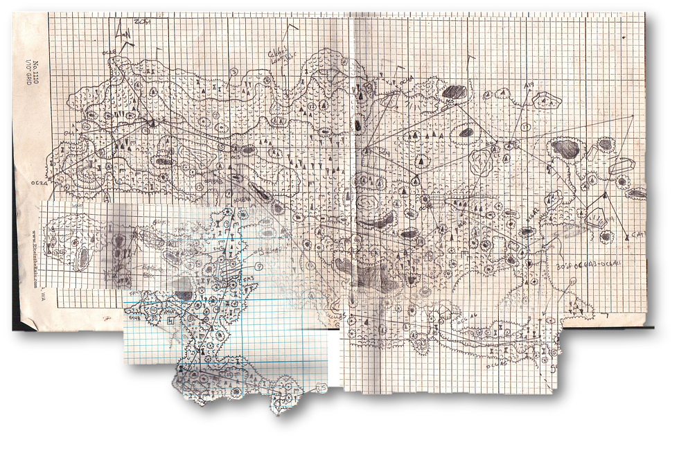
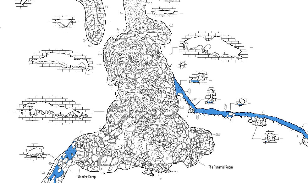
In 1912, the State Geological Survey of Tennessee began to prepare reports on all the “important” caves of Tennessee showing what deposits occur in them, the life inside, and any value they may have to the State. In August of 1912 an article with a partial map of Wonder Cave was published. The state did not complete their survey of Wonder Cave and only surveyed to an area known as the “Pyramid Room”.
After just over a decade of using boat tours to enter the cave, in 1914 Robert blasted and dug a new tunnel entrance into the cave. The new entrance was dedicated to one of the original discoverers, Will M. Fitzgerald. They had a dedication celebration with a large community picnic and special priced tours of only $0.50, regular tours at that time were $1.50. All of the proceeds from the days tour were donated to the Monteagle sidewalk fund.
In 1915, the plans to construct the Dixie Highway began. The Dixie Highway is a United States Automobile highway that was planned to connect the US Midwest with the Southern United States. Grundy County was originally excluded from this highway so R.M. Payne offered to donate his toll road to become part of it if they would take the road through Grundy County. Payne knew the new road would allow for thousands of travelers to pass right by Wonder Cave! Today the Dixie Highway is 5,786 miles long.
On June 28, 1917 Robert Marion Payne passed away and in his last will & testament he appointed a board of trustees to run the business of Wonder Cave. According to his will, the trustees were to sell the Wonder Cave Property after 21 years with the proceeds of the sale to be equally divided among his heirs. This goes back to why his family sold the hotel after his death as mentioned earlier in the article. They were not allowed to sell the cave because of the clause in Robert’s will but there was no mention of such a clause on the hotel. After Robert’s death, his was survived by his wife Emma Elizabeth Payne, his son Charles Buford Payne, his daughter Katie Payne Sayles and his granddaughter Mary Orme Sayles.
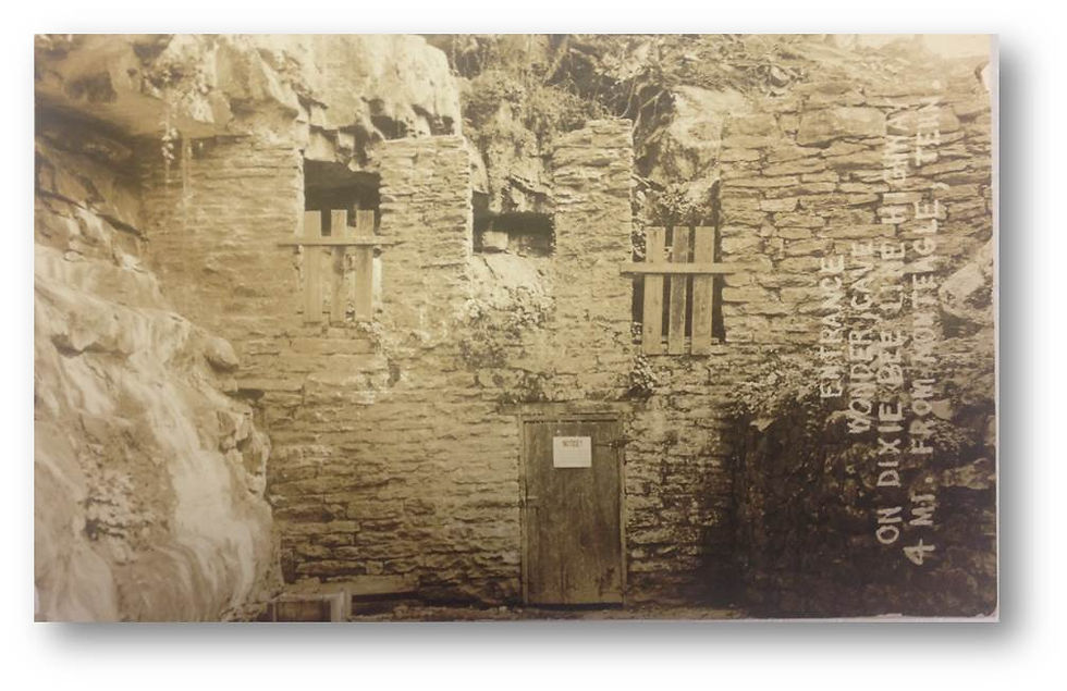
In 1927, Robert’s granddaughter Mary Orme Sayles married Jefferson Jones (JJ) Raulston. In 1928, Robert’ only son, Charles Buford Payne committed suicide by swallowing mercury. In 1929 J.J., who was also known as "Jonah", took over the operations of Wonder Cave for the Payne family. To help promote the cave J.J. constructed a two- story log house near the cave's entrance. This impressive building held a gift shop and ticket office and even served as his personal residence. Visitors could now buy items such as postcards, bells, matchbook covers and other trinkets adorned with the Wonder Cave name. During later years the building functioned as a bed and breakfast. J.J. also erected a beautiful stone entry facade leading to the cave that still stands today. Both of these structures would later be added to the Register of National Historic Places in 1987.
During the 1940’s Wonder Cave was visited at least on two occasions by Dr. Henry T. Kirby Smith. He was a Sewanee physician & caver who kept a very detailed journal of caves in the region. His family owned Wet Cave and as a child he regularly visited Wet cave and others with his father. After moving away for a while, he later returned to the Sewanee area in 1940. Dr. Kirby Smith’s written observations are in many cases the first ever made for a number of Tennessee caves. In one such journal entry on June 1946 he noted that he entered the cave with Harvey & Jim Templeton, and two of the “Raulston” boys. They proceeded beyond the swim, up and over the Pyramid Room and to the passage he describes as to the left. His notes read, “It starts as a low solution channel which runs into a larger channel at rt. angle. It is a large dry passage which has fallen in and under it a stream is seen in a couple of places. This passage is about ½ mile long and at the end after a low stooping area is a fairly long room with a large free running stalagmite and flowstone. No evidence of previous exploration at the end.”
J.J. and Mary had three sons and one daughter; Frank Raulston, Hugh Sayles Raulston, Marion Greer Raulston and Elizabeth Orme Raulston. It is noted throughout the cave that Mary and her three sons visited the cave on September 2, 1945. Their signatures can be found atop the Pyramid Room and even in the far reaches of the north passage of the cave.
On December 27th 1953, Tom Barr along with Bill Cuddington, Roy Davis, Frank Raulston and a few others spent seven hours in passages beyond the Pyramid Room making additions to the 1912 map produced by the Tennessee Division of Geology. They did produce a complete map of the main passage of the cave but the 2015 survey by Jason Hardy showed that they were a bit off on the direction the cave was heading. For many years, it was speculated that the cave headed eastward into Layne Cove and this is what Tom’s map reflected. Tom mentions the cave in his 1961 book Caves of Tennessee and he also published his map in it.
In 1960, J.J. purchased a new ticket office for Wonder Cave. He purchased the kit from a Sears & Roebuck catalog. The new ticket office offered modern conveniences such as public bathrooms!
Due to age and failing heath, J.J. & Mary’s son Frank Raulston took over the management of Wonder Cave in 1963. Records at that time show the annual visitation was around 40,000 visitors a year. Robert’s plan back in 1915 to donate his toll road had paid off for his family but that would soon come to an end. Two years after Frank took over managing the cave, his mother Mary Orme Sayles Raulston, passed away. In 1965, Mary’s mother, Katie Payne Sayles passed away and in 1967, Jefferson Jones Raulston passed away. Within a very short time span the family had suffered numerous losses. Now the only remaining descendants of Robert Marion Payne were his great grandchildren; Frank Raulston, Marion Greer Raulston, Elizabeth Orme Raulston and Hugh Sayles Raulston.
Frank continued to manage the cave after the death of his parents. He became a member in the National Caves Association, which is a non-profit trade association founded in 1965 by a small group of private show cave owners. These initial members sought to bring together show cave owners and operators from across the United States to promote the show cave industry to the public, to share information and ideas, and to lobby for legislation favorable to the show cave industry. He even had barns along Highway 41 painted with SEE BEAUTIFUL WONDER CAVE. For many years, even though there seemed to be no limit to the number of signs for Ruby Falls along US 41, Wonder Cave attracted more tourists than Ruby Falls or Raccoon Mountain Caverns. It simply had one major advantage. It was the first major roadside attraction for northern travelers heading south. Many tourists were able to get their first glimpse of the Cumberland Plateau here and preferred to stop at Wonder Cave rather than continuing to the caves near Chattanooga. But no matter what Frank did he was not going to be able to stop the inevitable, Interstate 24.
During the early 1960’s Interstate 24 was being constructed and with it, Wonder Cave would no longer be a short quarter of a mile off the main road but instead a 7 mile detour off the interstate. Interstate 24 drastically altered visitation and when it opened visitation decreased by nearly 90 percent. This marked the demise of the site's status as Tennessee's most popular show cave. While times were slow, Frank continued to manage the cave until his death in 1980. Wonder Cave was slowly being forgotten about and popular tourist attractions such as Ruby Falls were now getting all the attention. Tourists passing by on Interstate 24 had no idea of the beauty lying within the Cave just a short distance away. For a few short years after Frank’s death the cave remained closed.
On April 01, 1987, Wonder Cave, along with 16 acres around the cave, the JJ Raulston house, the Wonder Cave entrance building, and the first mile of cave were added to the National Register of Historic Places for its significance in architecture and tourism in Grundy County, Tennessee.
Also in 1987, 70 years after the death of Robert Marion Payne the cave was finally sold by his heirs. The new owners, the Born Family, were out of Chattanooga. The cave was re opened and the owner’s sister, Julia operated the cave off and on during the summer months. She lived in the JJ Raulston House until she married in the year 2000 and moved away. After she moved the cave closed once again and still remains closed to the public today. It has been recorded that more than two million visitors toured Wonder Cave between 1897 and 2000. Perhaps this is a good thing. After all, the 2 million plus visitors over the century it was open must have had some type of negative impact on the cave.
Fast forward to 2013. I have always had a fascination with caves and history. Wonder Cave had been on my radar as a caver as a place to hopefully one day visit and I had only dreamed that Jason Hardy and I would have the opportunity to survey it. We were in the midst of planning our wedding and I decided to reach out to one of the sons of the owner. I spoke to him on several occasions asking if we could be allowed to have our wedding on the property but did not have much success. It was a few years later when Blaine Grindle phoned me to say, “There is a party at Wonder Cave this weekend.” Blaine works for the Forestry in Monteagle and one of his co workers lives near the cave and had told him about this party. Having already purchased tickets to go see the Dalai Lama in Birmingham on that particular day, we asked Blaine to go and talk to the owners about surveying for us. There was still hope! Blaine, his wife Anne and a few others made their way to the party that day, met with another one of the owner’s sons who gave them a tour of the cave. However, they were asked how they heard about the party because it was considered as a private event, OOPS! But it was the “in” we needed because this particular son was extremely interested in learning more about surveying and having us produce a map of the cave for him. We were put in touch with him and Jason visited his place of business in Chattanooga. They sat down together and Jason explained to him the survey process and showed him some of his other maps that he had drafted. With permission granted and keys to the gates in hand we were very excited to have finally been given this wonderful opportunity to survey this very special cave.
On December 13, 2014, we made our first survey trip into the cave. It was myself, Jason Hardy, Blaine Grindle and Anne Grindle. After taking a quick tour of the tourist section of the cave we began our survey back at the entrance. We surveyed about 500 feet and made our way to an area referred to as the “Great White Way”. It was named this because when the cave was lit with acetylene gas the walls glowed and appeared to be white. For many years prior to starting the survey, I had collected a good number of old postcards of Wonder Cave. It is from these postcards we were able to learn names of passages as they were called during the cave’s heyday.
January 3, 2015 we returned to pick up where we left off. This particular day it was Jason Hardy, Anne Grindle and I. We surveyed past the “Devil’s Playground”, which is an area with very large anastomosis and was depicted in a lot of old postcards. We then made our way up the “Giant’s Stairway” and into the highly decorated tourist section in the cave.
During the first two trips, 100 foot survey shots were common. We knew this next section would bring some complexity with all of the formations, especially due to their size. Because of this Jason knew he would need some help with surveying this cave so he enlisted Ben Miller, Josh Brewer and Clint Barber to help with some of the sketching. After our trip on January 3 we had two inches of rain overnight. We were quite surprised the next day when we returned on January 4 to start our work in the formation area of the cave. Ben Miller, Katie Ingram, Josh Brewer, Jason Hardy and I all made our way into the cave. We immediately noticed even before going in the cave the water levels coming out were up. When we reached the section leading up to the Giant’s Stairway the water was waist deep on me. Now granted I am only 5 foot 2 inches tall but the water was 3 feet lower the day before! It was at this moment that Ben looked at Jason and said, “I thought this part of the cave was dry!” We pushed thru because we knew where we were going would be dry because it was higher ground in the cave. We spent the next few trips surveying this section of the cave as there was a lot of detail that needed to be drawn. During the survey of this area I noted a lot of old broken flash bulbs, a few old wooden walkways that were constructed across gaps in the floor, an old tip from the acetylene gas system that was once used in the cave, a glass globe from a lantern, historical signatures and even pieces of an old explosives box!
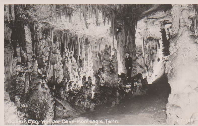
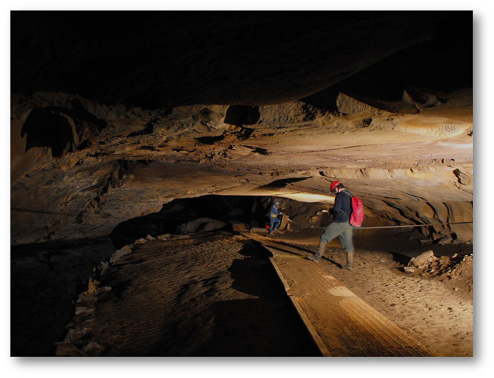
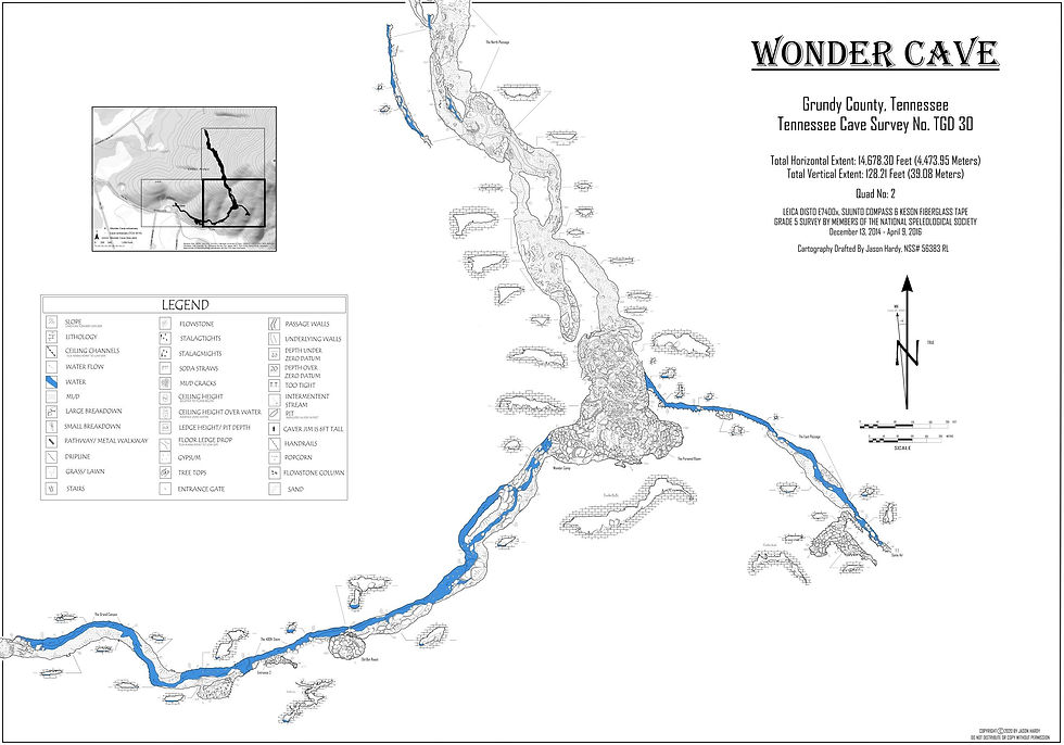
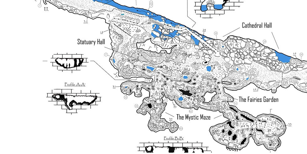
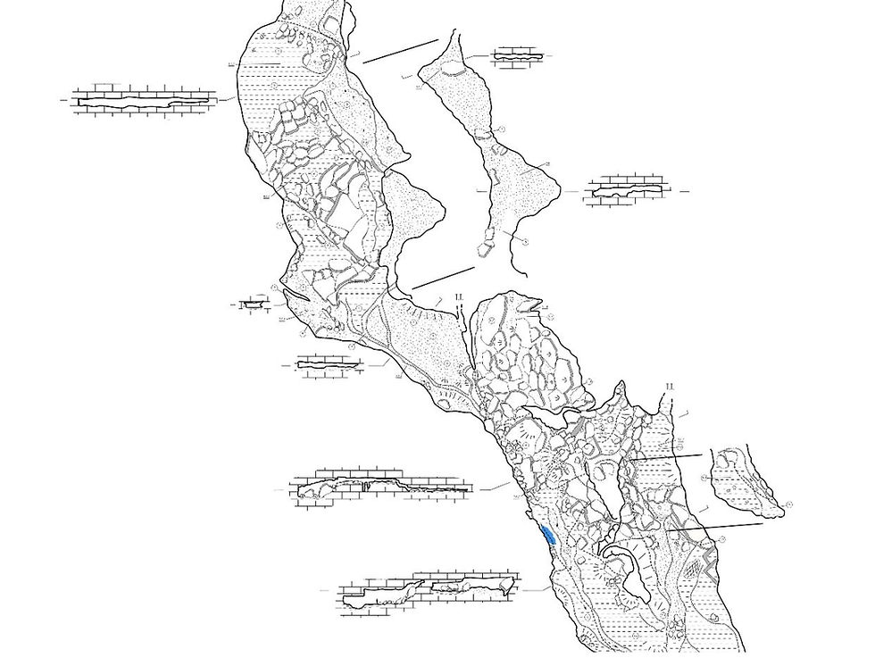
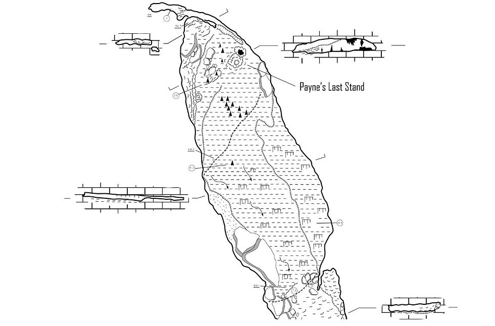
This area was obviously the main tourist attraction in the cave. It is an upper level that is located 30 feet above the stream level. It ranges from 15 to 20 feet high, 30 to 80 feet wide and is 350 feet long. The area is divided into two principle chambers; Statuary Hall and Cathedral Hall. Large massive flowstones and large massive stalagmites can be found throughout this section. When Robert Marion Payne commercialized the cave he used formations to make stairways and blasted rocks to make trails. There are two paths that lead into this area essentially forming several loops. One can spend many hours finding formations that resemble above ground objects such as a turtle, a shark, a loaf of bread, a Priest at his alter and even an old goat!
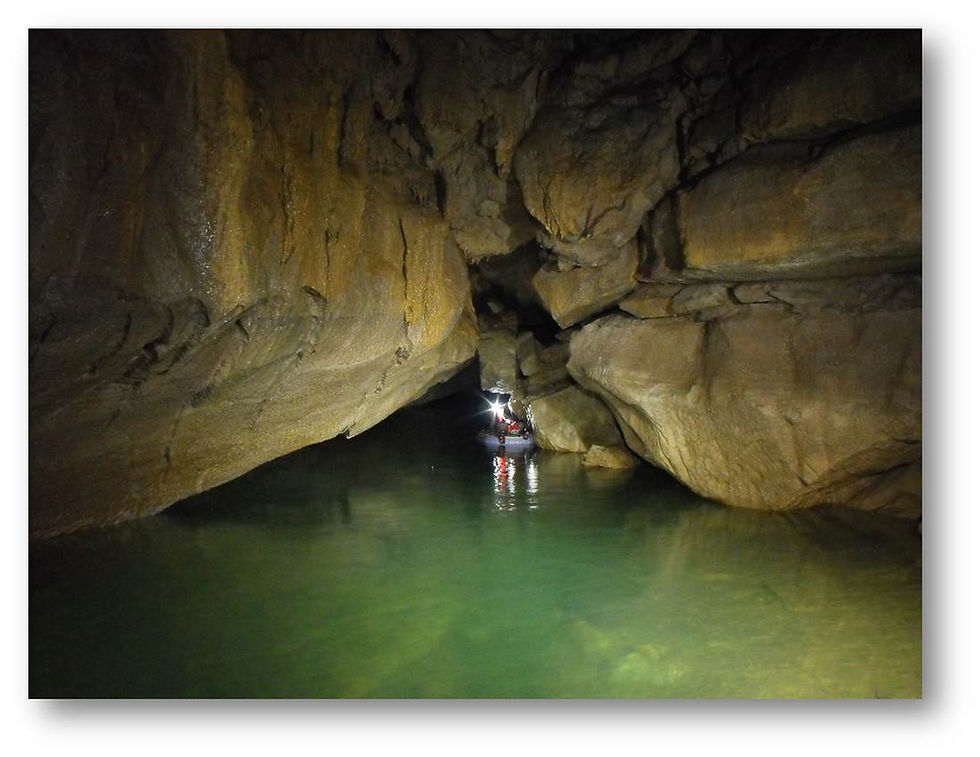
Once we were finished surveying in the formation gallery we were ready to continue the survey down the main passage of the cave. For the most part, when Jason and I survey a cave we survey as we go. This is always true when a cave is virgin but even when it’s not we typically will still follow this rule. It keeps the excitement going for the surveyors to never know just what is around the next corner. We had heard about a swim beyond the formation gallery but had not seen it yet. Our next survey was scheduled for February 14, 2015 and we knew we were close to the swim so with us we brought not only wet suits but blow up boats. On this particular day it was Jason, myself, Shari Lydy and Stephen Collins. We brought our boats into the cave with us but just before going in we decided to give them names, the S.S. Hardwood and the KVPDLR. It wasn’t long before we reached the swim area. We paused for a bit to contemplate the best way to survey through this section. It did not take us long before we realized the blow up boats were just not stable enough. After a few flailing attempts we decided to call it a day and come back with a better plan.
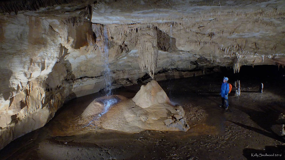
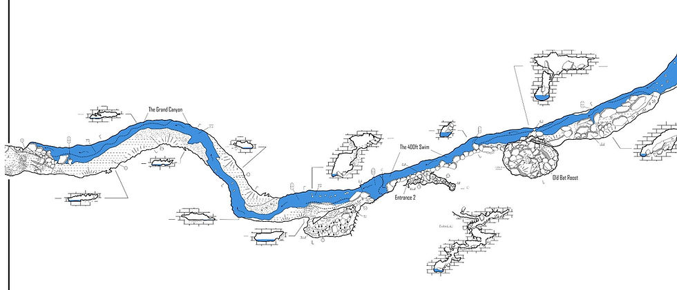
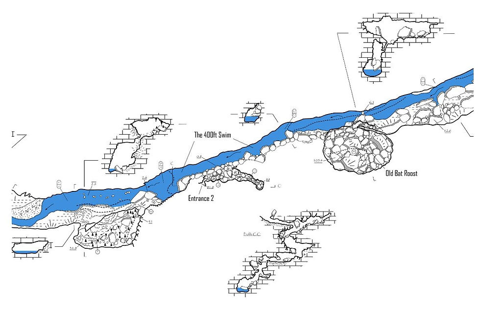
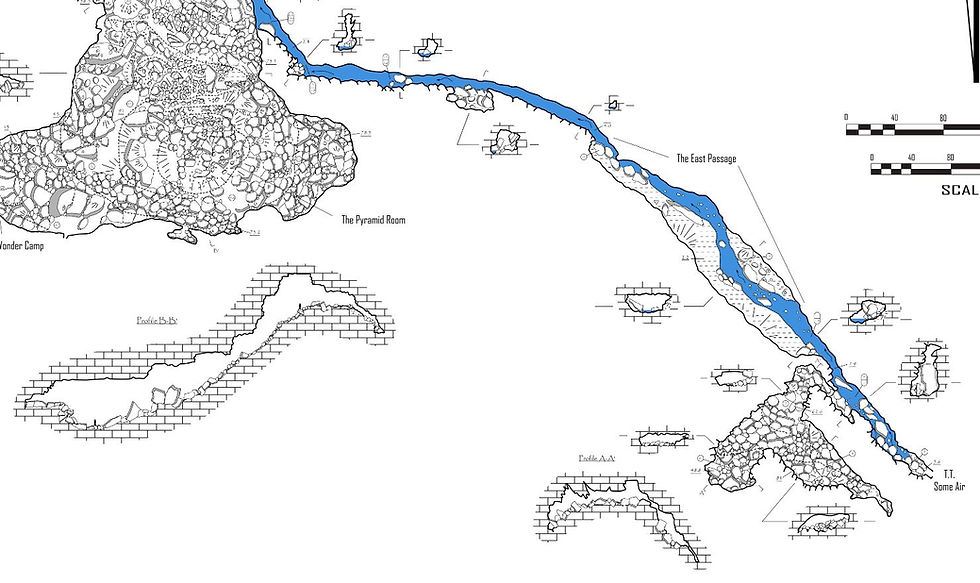
It was just over two months before we had the next opportunity to return to our survey in Wonder Cave. On April 18, 2015 Jason, Ben Miller and I donned our wetsuits and came prepared to get thru the swim with inner tubes. We found that the inner tubes worked much better and allowed us the stability to set stations and read instruments while floating in the water. It was not easy but easier than using the boats. We surveyed our way through the swim section, which ended up being about 400 feet long. It is a long narrow passage with a sloping left wall that has large pieces of breakdown in the water. We learned the hard way that if one were not careful going around the breakdown, the sharp edges of the rocks could easily puncture your inner tube. The water throughout the swim passage is deeper than I am tall, over five feet. Using inner tubes and swim fins was going to be the most efficient and quickest way to navigate the swim passage going forward. After we surveyed through the swim we continued on for another 500 feet or so until we reached the base of the “Pyramid Room”. The Pyramid Room is a large room filled with breakdown. The measurements of the room are approximately 450 feet wide, 350 long and 130 feet tall. The center of the room is filled almost nearly to the ceiling with large breakdown in a pyramid shaped pile. Ben, Jason and I spent some time discussing our plans for a return trip and concluded that since we had to go through the swim passage each time to get here it would be well worth our time and effort if we did a camp trip or two in the cave to survey this area.
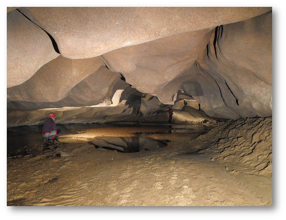
After a little bit of planning and getting folks on board we decided on the weekend of May 23 & 24, 2015 for our first camp trip in the cave. Joining Jason and I for the camp trip was Ben Miller, Katie Ingram and Josh Brewer. Also joining us that weekend for the camp trip were the Aulenbach’s; Brent, Nancy & Scout. They however opted to do the swim in and out and camp on the surface Saturday evening while we camped inside the cave. Tevis Kouts and Dona Seyler were in town and also joined us for the day on Saturday May 23rd. Packing for the camp trip was interesting. This was the first time that I had ever camped in a cave and I had a good idea of what to expect from all of my caving experience. Jason and I used the large Darren drums and another large drum he had for all of our clothing, food and camping gear. We had planned to dress as sparingly as possible going in and used the boats, boogie boards, swim fins and inner tubes to get each of us through the swim along with all of our gear. Once we all arrived at the small area at the base of the pyramid room Ben immediately said, “Welcome to Wonder Camp, where men become boys!” After we all had a good laugh we changed out of our wet clothes and into dry ones, set up tarps and our camp areas and then got to work on surveying the Pyramid Room. We divided into three teams for the day: Jason, myself & Dona, Ben, Josh, Katie & Tevis and team Aulenbach.
While Jason, Ben & Josh worked with their teams surveying and sketching the Pyramid Room, the plan for the Aulenbach’s was to start surveying into the main passage beyond the Pyramid Room. Since none of us had been here before we only had a general idea of where the passage led off the room and a great story to go with it. When we had first met with the current landowner of Wonder Cave he told us that when he bought the cave he was told that JJ Raulston was buried in the cave. He swore to us that he had seen the grave himself. Being a bit skeptical we were not sure about this but I did do some research and was never able to locate the real grave above ground for JJ. As I was helping Brent, Nancy and Scout to find the main passage heading off we heard Brent shout back, “I found the grave!” We pondered over it for a few minutes speculating if anyone was actually buried there or not. There was a small mound and what seemed to be a headstone. We wanted to keep a good story so we never disturbed this area during the entire survey.
Hours passed and we decided to break for a hot meal. One by one we made our way down the Pyramid Room back into Wonder Camp. We heated up our lunches, chatted for a bit and then got back to work surveying. Soon it was getting late and the Aulenbach’s started heading out for the night, along with Tevis & Dona. Unknowingly to us at the time Scout would experience a blow to her blow up boat on the way out in the swim. Nancy & Brent were quick to rescue her and once back on the surface they patched up her boat for the return trip the next morning. We eventually found a stopping point ourselves and called it a night. It was interesting sleeping in a cave for the first time. Here I was next to this huge breakdown pile and all I could think about was the ceiling fifty feet above me. Every time I heard a droplet of water hit my tarp I would think, “Is that a rock?”
The next morning we were awoken by the sounds of voices coming down the passage. It was the Aulenbach’s returning to finish up a loop they had started in the main passage the day before. We got up and cooked breakfast and then got to work surveying again. After 30 hours in cave we decided to stop for the day around 3pm, pack up and head out of the cave. Once back on the surface the Aulenbach’s headed back home to Georgia and the rest of us decided to head up to Monteagle to eat at The Smokehouse. No sooner than we had walked in the door we heard, “Want a FREE RIB?” We of course were all over it. I mean after all, who can turn down free food after being in a cave for 30 hours and only eating dehydrated foods? We had a great dinner and discussed another return camp trip for June.
June 27th, 2015 we met up with Ben Miller and Josh Brewer. Katie had to work so was unable to join us again but also joining us this time was Hali Steinman. Our goal for this trip was to finish up survey in the Pyramid Room and move on to the rest of the cave. We knew going in the cave that Hali would be celebrating her 22nd birthday with us during this camp trip so Jason wanted to make it special for her. We bought a pre made frozen coconut cake and had packed it in a large pelican case that morning. Along with it we also packed crackers, cheese, summer sausage, margarita mix, tequila and some various other snacks. After getting thru the swim and into Wonder Camp we all set up our tarps and got to work surveying in the Pyramid Room. We broke for a hot lunch and then finally again for a late dinner. After eating, Jason brought out the cake! Hali was quite surprised. However, we only brought 11 candles so we had her blow them out twice while we sang to her. It was a very memorable night. The next morning we awoke, cooked our breakfast and split into two teams picking up where the Aulenbach’s had left off on the previous camp trip. Feeling successful with the weekends work after surveying for about six hours we called it a day on another 30 hour camp trip in the cave.
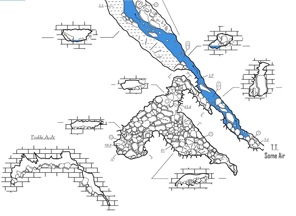
Our next trip would only be a day trip, August 29, 2015. It had been a while since Blaine Grindle had joined us on a trip and Anne Grindle had not joined us at all at this point so they along with Brent, Nancy & Scout Aulenbach came out to help. Jason, Anne, Blaine and myself had planned on surveying some side passages that we did not get to on the last camp trip, while the Aulenbach’s picked up where we left off in the main passage after the last camp trip. We knew rain was in the forecast for the day but did not expect to receive enough to call off the trip. We had already learned on one previous trip back in the winter what 2 inches of rain could do to the cave and we certainly did not want to experience flooding having to go through the swim. Our team had a very productive day surveying two side passages, including finding a passage that headed east. After you pass the Pyramid Room, the cave makes a turn and starts trending north. Most cavers always just assumed that the cave trended in an eastward direction into Layne Cove. It was during the first camp trip when the Aulenbach’s were surveying that Brent notified Jason of this. So every since then we had kept our eyes out for a passage heading east. There was a short climb down just before the trunk passage heads off the Pyramid Room so this was our potential to head east. After Jason, Anne, Blaine and I had surveyed our two side passages we decided to take a peak down into this area to check it out. After crawling under some breakdown, there is a sketchy 15 foot climb down. We rigged a hand line using webbing and down went Anne and Blaine. She quickly encountered the stream and was giving details back to Jason and I who waited at the top of the climb down. After a few minutes she returned and reported that she went a few hundred feet and did not see an end. She also noted that she was in stream passage at least waist deep in some spots. We knew we were not dressed properly to survey this passage today so we made plans to return with wet suits and to bring a rope to rig a fixed hand line for safety. As we began heading out for the day it became obvious it was raining on the surface. Going through the swim there was water coming out of the ceiling everywhere. It was actually really neat going thru this 400 foot long swim in an inner tube with water coming down like rain. Almost felt like you were in a magical jungle somewhere! As we were going thru the swim we could hear the Aulenbach’s coming up behind us. Once through the swim they informed us of their experience in the back of the cave and the water coming in through an in feeder back there. They had hoped to finish the area they were surveying in but the water was too much of a risk so they opted to route. As it turns out it was perfect timing since we were on our way out as well. Once back on the surface we used the old ticket office to get into dry clothes and have a few snacks before calling it a day.
Our next trip would be the following month in September. Jason and I returned with wet suits to push the passage heading east off the Pyramid Room. With high hopes we surveyed this section for about 800 feet before it pinched off with breakdown and water coming out underneath, classic ending in a TAG cave! It is noted however that the water in this passage starts off shallow but does get deep in some areas, at least chest deep on me. Jason pushed an upper side and found an upper level area that he knew he would later return to survey with Dutch Sanders. Jason noted on the return trip that the water was so high it was literally walking in water with ear dippers in some places. It was also on this trip that Dutch found another upper side passage with large mounds of guano. We contacted Cory Holiday who came out in April of 2016 to take a look. Cory had long suspected there were a large number of bats using a cave in this area so was excited to find out. However as it turns out the guano was old, estimated to be at least 100 years or more by Cory.
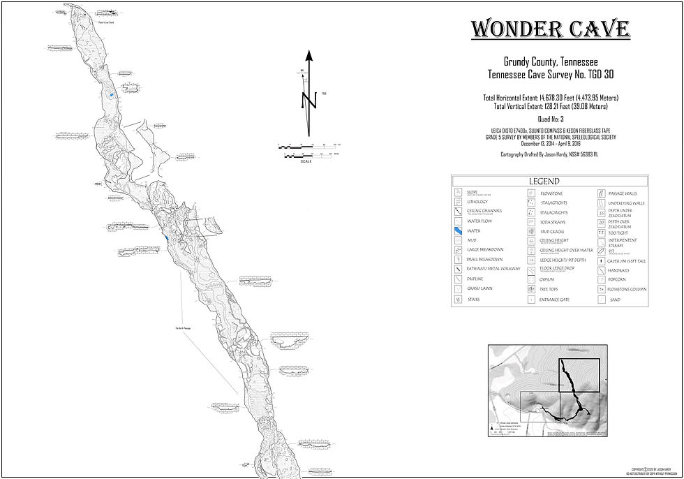
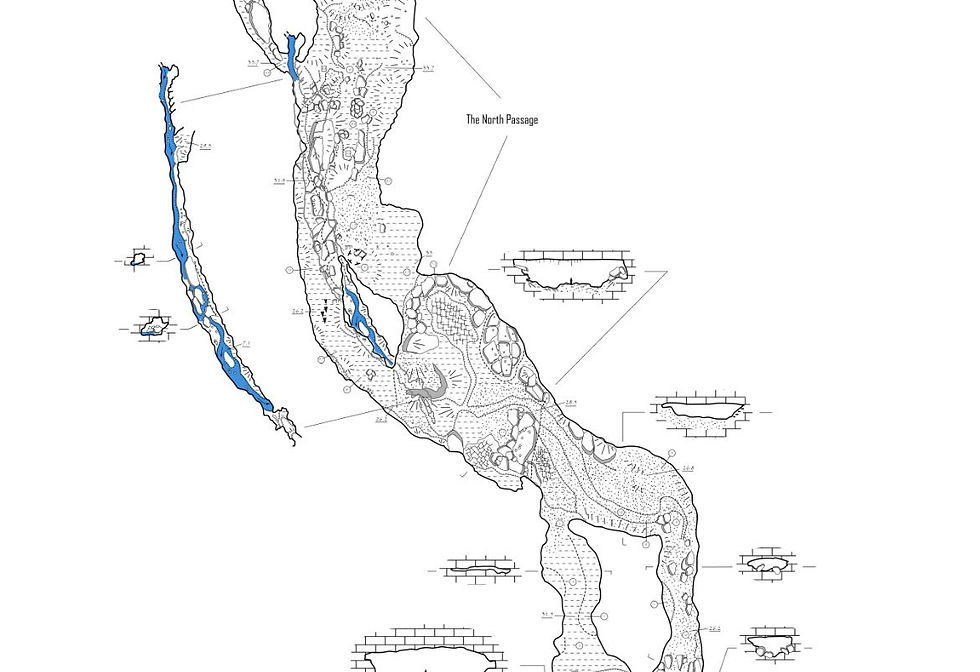
November 21, 2015 we returned to pick up in the main passage where the Aulenbach’s were surveying back in August when the rain started. We knew at this point we were getting close to the end of the cave. Travis Camp and Hannah Keith had joined us on this day and we surveyed a few hundred feet before reaching the end of the main passage. At the end there is a rather large flowstone in the middle of the room with an in feeder coming in from the ceiling, which we named Paynes Last Stand. After pushing every nook and cranny in this area we knew we had finally reached the end and would only have some side passages to mop up to finish the survey.
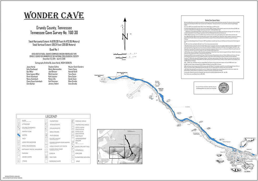
Over the next few months we finished up every side passage and were officially able to call end of survey on Wonder Cave in April 2016. Overall we set approximately 400 stations or a total surveyed length of 14,678.3 feet. Wonder Cave was previously listed as 7,000 feet long in the Tennessee Cave Survey. It is now listed as the 58th longest cave in Tennessee where it was previously 149.
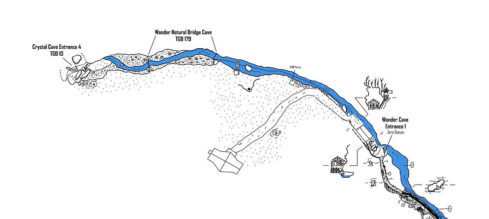
After completing Wonder Cave, Jason Hardy began the survey of Crystal Cave which hydrologically connects to Wonder Cave. The Mystic River as it is known flows out of Wonder for about 200 feet, goes into what is known as Wonder Natural Bridge Cave for 100 feet, back out on the surface for another 200 feet and then into Crystal Cave. Crystal Cave is listed as 4,000 feet long in the Tennessee Cave Survey and has four entrances. We expect to get a least a mile out of the survey and over four miles out of the entire Wonder & Crystal Cave complex.
Please note that we have permission from landowners to complete the survey of both Wonder Cave and Crystal Cave. They are both privately owned and are not open to the public. Please do not visit these caves without permission from the owners.


My grandfather used to manage Wonder cave. I do not know dates, but probably late 1800's early 1900's. His name was Andrew Jackson Rollins.